Expletive deleted

Cadigal Reserve, Summer Hill

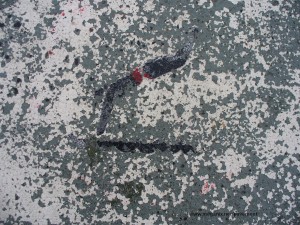
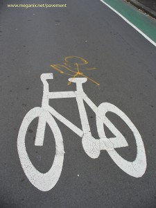
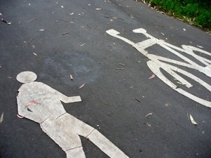
The signs, symbols and graffiti on the ground are all evidence of a territorial battle that is being waged among government authorities, property owners, motorists, cyclists and pedestrians. Now the stencils themselves are getting in on the act. It is clear that this walker has cracked up and has said something sharp to the bicycle. But a zealous graffiti obliterator has painted over his speech balloon and now we’ll never know what it was he said.

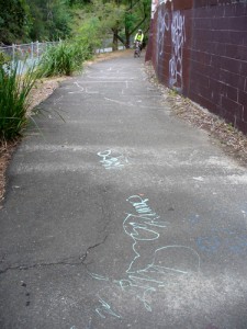
These particular stencils are on a pathway in Cadigal Reserve in Summer Hill. The pathway continues along beside Hawthorne Canal, which eventually runs into an arm of Parramatta River. 

The canal has a history of successive waves of pollution. Originally a stream called Long Cove Creek by early European settlers in Sydney, by the late 1800s it was fouled with house slops and the run-off from factories and slaughterhouses. The stink that it gave off was considered to be a health hazard and eventually it was excavated, re-aligned and lined with concrete in 1895 and renamed Hawthorne Canal.

But over the years the stormwater it collects has still been polluted with leaking sewage and dirt, horse manure, oil, chemicals, plastics, heavy metals and garbage washed off the roads and nearby rubbish dumps. And then, some time in 1990s, the canal was subjected to what some people regard as visual pollution – graffiti.

Hawthorne Canal, Summer Hill

Taggers and graffiti artists continue to express themselves on the walls and under the bridges there. Their marks have spread to the pathway beside the canal. Government authorities and a bush regeneration group have done much to improve the banks of the canal in recent years, so it is understandable that they might want to remove ‘unsightly’ graffiti from the asphalt. They can’t win though. More pavement graffiti has appeared since the last applications of grey paint. But I wish I had been there before they covered up that pedestrian’s outburst.

(Some of the information for this post was obtained from Hawthorne Canal – the history of Long Cove Creek, written by Mark Sabolch and published by the Ashfield & District Historical Society in association with the Inner West Environmental Group in 2006)
Writing on water – thoughts from Silverton (Guest spot)

This week’s post was written by guest spotter Julian Holland, who is a science curator and historian. Julian has been travelling recently in far western New South Wales.

Water – and there is a steady insistent drizzle as I write – water remains the central conundrum of the European experiment in settling Australia.  Water is invisible in most of the Australian landscape most of the time.  But sometimes – at rare intervals – it appears in abundance, even excess.  Much of the drive for Australia’s exploration in the nineteenth century was the search for water – for an inland sea around which agriculture could develop and for navigable rivers which could transport people and produce to markets.

But the explorers’ quest gave way to the reality of Goyder’s Line, the boundary in South Australia beyond which rainfall could not be relied on for agriculture.  The disjunction is marked on the landscape by a sudden shift in the character of vegetation.

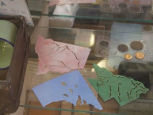
Yet the myth of water remains powerful.  In the old school house museum in Silverton, beyond Broken Hill, plastic stencils of different states reminded me of this.  Apart from their boundaries – coast lines and surveyors’ lines – the only features they could guide a child’s pencil along were the courses of rivers and boundaries of lakes, patterning impressionable brains with the idea of water in the landscape. 

But South Australia’s lakes are salt pans.  And perhaps the stencil-joints along the rivers should be read more literally.  Australia’s rivers are often no more than strings of waterholes.

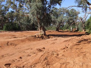
The river that runs through Silverton, Umberumberka Creek, most of the time doesn’t run anywhere.  It is a river of sand.  It is characteristic of Australia’s dry land rivers, visible in the landscape as a ribbon of larger trees, their roots embracing the invisible river below the sand. 

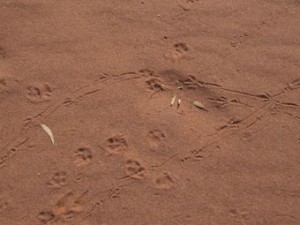
Instead of the ephemeral ripples of wind or insect or falling leaf – or the splash of oars – these rivers of sand carry slightly more enduring inscriptions.

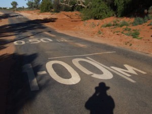
Heading back to Broken Hill, on the outskirts of Silverton, the road bows down in courtesy to a passing creek – a feeder to the Umberumberka – dry too much of the time to warrant a bridge, the possibility of water, or the probability of its absence, marked by lines and depth measures of 0.50 and 1.00 metres.  We inscribe the landscape and the landscape is inscribed in us.  The two landscapes do not always match.

Urban versions

Graffiti Tunnel, Waterloo

On the last day of the Royal Geographical Society Annual Conference in London, a group of delegates went on a field trip to study ‘urban subversions’. They watched parkour practitioners on the South Bank, skateboard tyros in the Undercroft, and graffiti artists in the Leake Street Tunnel at Waterloo. In the tunnel they were obliged by me to take note of what was on the ground as well as on the walls.

Thanks to organisers Oli and Brad, this was all very interesting, but I’m afraid my eye was drawn away to rather ordinary chalk marks that had almost certainly been left by hash house harriers. I’ve mentioned this urban version of cross country running before. Recreational runners may not be exactly subversive but they do extend the range of uses of streets and public spaces. And as they pound through the city in the early hours of the morning they leave pale traces of their passing in the form of chalk arrows and symbols.

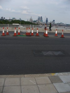
Chalk arrow on Waterloo Bridge

Chalk mark at the Undercroft skateboarding area on South Bank

Exhibition Road experiment

Exhibition Road in London is a mess. In a busy cultural precinct, it runs past the Victoria and Albert Museum, the Natural History Museum, the Science Museum and the Imperial College, and links South Kensington Station with the Royal Albert Hall and Kensington Gardens. But right now, from one end to the other, there are barricades, wire fences, earth moving equipment, temporary traffic lights and improvised pedestrian crossings.

It’s all part of a big experiment, with Exhibition Road planned to become the first shared-space street in London. Apparently the local residents are not happy with the scheme, presumably because they are less interested in accessibility for cultural tourists and more interested in parking spaces and easy access to and from the area for their very flash motor cars.

According to information posters hung from the wire barriers, the street will have “a kerb free single surface” and “visual and tactile lines distinguishing pedestrian areas from those used by vehicles”. Just this week workers have begun to pave some areas of the street with artificial cobblestones, forming geometric patterns in a range of designer greys. Road users will have to learn to read these patterns. When the work is all finished the paving will have become the instructions for its own use.

Pole position

Photo by Bradley L. Garrett

How did workers know where to install street furniture before the invention of the downward squirting spraycan? Can you remember when pavements were not dotted with instructions for the placement of bus seats, pram ramps, traffic signs, trenches and power poles?

London-based place hacker, Bradley L. Garrett sent this photo of promise and fulfilment. Congratulations to Brad for his geometrically artistic patience in waiting for the precise alignment of the shadow.

Crime story

Princes Highway at Brodie Sparks Drive, Wolli Creek, January 2010

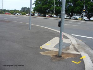
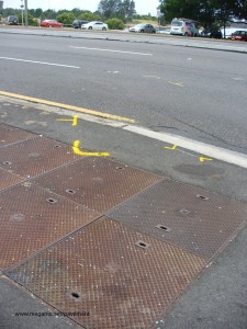
See, there were these armed robbers being chased by police, and they ran a red light and crashed into another car, and two people were trapped in the wreckage. And the robbers, see, they jumped out of their stolen car, and … well, if you can’t read all this off the yellow marks sprayed by police on Princes Highway at Arncliffe, then you’d better look it up in the paper.

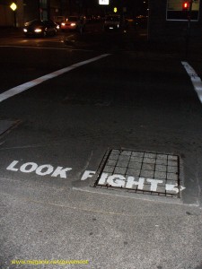
Look fight

Look! There’s a fight going on down the street. That’s what this sign seems to be saying. And it’s true. There’s a constant struggle for territory going on in the streets and almost every sign, symbol, graphic and graffiti marked on the roads and sidewalks is evidence of this struggle.

I made a video (actually, a photo compilation) on this topic last year. Called Street Writing, it’s been published in the on-line Interdisciplinary Themes Journal. Turn your sound on while you watch.

Hicks, Megan. 2010. Street fighting. Interdisciplinary Themes Journal, 1(1).

The ‘Look fight’ photograph was taken several years ago in Harris Street, Ultimo (Sydney). I’m delighted to say it’s been added as a guest photo on the ‘Submissions’ page of one of my favourite websites, Misplaced Manhole Covers.

Unselected readings

Starting point - Smith Street, Surry Hills

In the ten years since I became obsessed with pavement inscriptions I’ve taken hundreds of photographs. With so many to choose from it’s not too hard to find examples to illustrate any point I might want to make when I write about the pavement as a medium for expression.

But what if I took a walk on an arbitrary route from an arbitrary starting point and photographed every picture, sign and scribble on the pavement along the way? Would that series of unselected inscriptions unfold as a coherent story?

I tried this as an experiment for the Open Fields forum at UTS (University of Technology, Sydney). I started in Surry Hills at a street with a very common name, Smith Street, and took a zig-zag route in a direction away from the centre of the city. I got as far as Waterloo, only about 2 km as the ibis flies, but I had taken more than 3 hours and photographed around 150 pavement inscriptions.

End point - Danks Street, Waterloo

I made a slide show of these Unselected readings in the order in which I found them. But here’s a confession: although I stuck to my arbitrary rules for the day pretty well, I did stop photographing every manhole cover and every wet cement inscription, because there were so many of them.

What did I find out from this experiment? Well, perhaps I will talk about that in future blog entries.

Hard judgement

In an earlier guest blog, Bradley L. Garrett revealed his excitement upon discovering a pavement penis. Well, there’s a lot of them about.  These examples are in the inner Sydney suburb of Redfern, where encroaching trendiness has turned a closed-off street beside the railway line into an official bicycle route and a parking lot for cultural-industry workers and the newer type of resident.

Older established residents and their offspring may well feel resentful. I choose to believe that these alterations of official traffic signs express a local belief that the car parkers and cyclists are wankers.